

Overview (2027)

Key Information


Duration
Minimum 2 years, up to a maximum of 5 years.


Location
 CRICOS: 106224C
Duration
Minimum 2 years, up to a maximum of 5 years.
Location
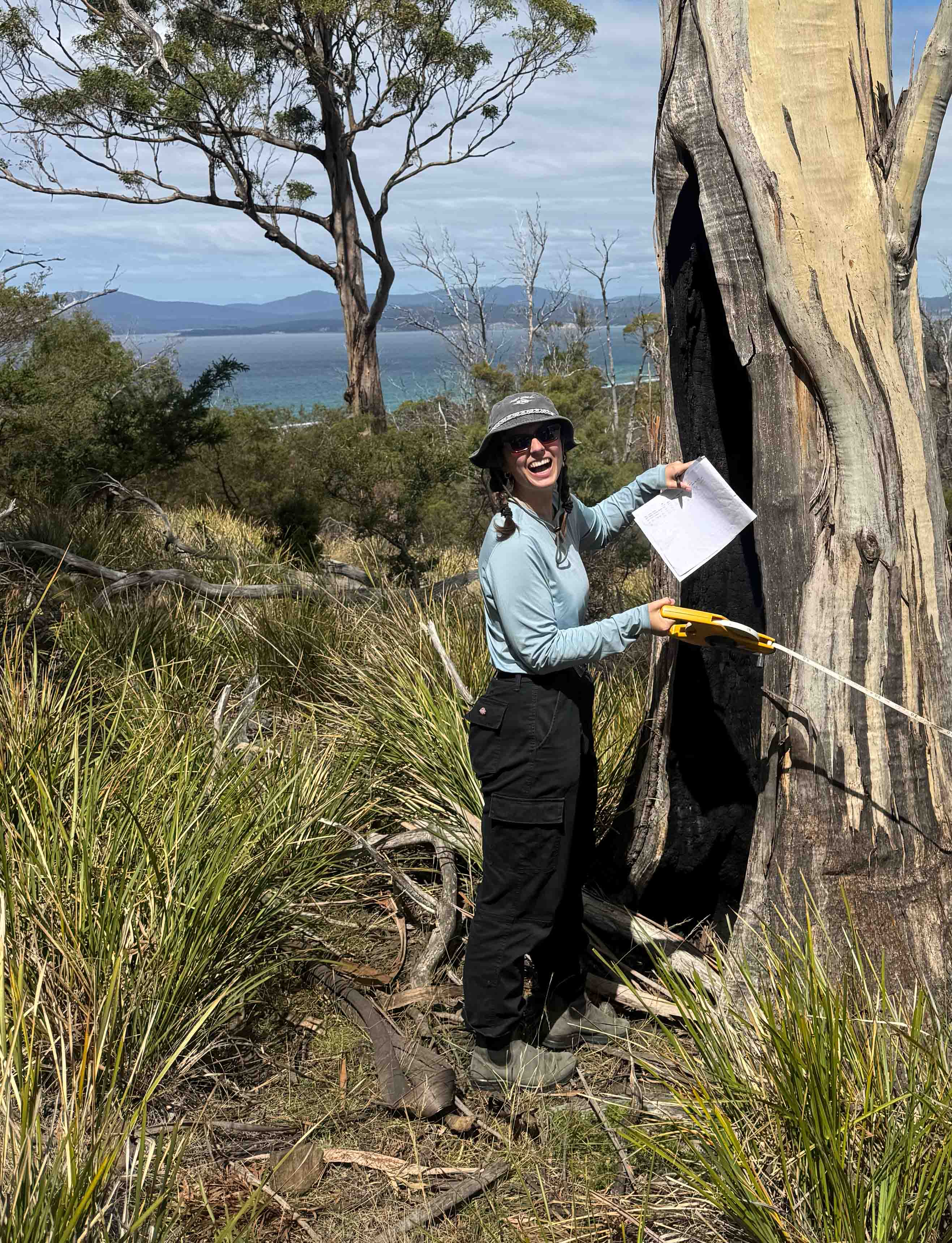
Jessica Smith - Master of Environmental Geospatial Science student
Environmental challenges are becoming increasingly complex, and problems like bushfire management and climate change require highly skilled professionals. Environmental professionals need to be able to analyse a variety of information, including mapped data, to adapt to current crises. Business as usual is becoming increasingly data-rich, and Tasmania’s Land Information System puts us in the fortunate position of being able to use geospatial information for many planning and day-to-day decisions across a wide range of sectors.
This course will teach you to integrate geospatial and environmental knowledge to make practical recommendations for enhancing decisions around places, from predominantly natural to highly urban. The unique combination of environmental and geospatial skills in a pragmatic, case-based learning environment will prepare graduates well for an exciting career.
You will apply skills in geographical information systems and remote sensing to address complex problems associated with managing ecosystems and fostering sustainable practices. These skills are in high demand by government and industry employers, and you will benefit from our close connections with the profession and work-integrated learning.
Graduates will possess the skills to tackle complex problems such as climate change and utilise spatial data to understand changing landscapes.
- 1 Synthesise theory and contemporary knowledge in environmental geospatial science fields to define problems and solutions.
- 2 Justify solutions to a range of complex environmental geospatial science problems by applying data collection and analysis techniques
- 3 Manage the design, documentation, and resourcing of geospatial science solutions in diverse environments workplaces, and across contested environment issues
- 4 Develop and justify your own positions on environmental geospatial science issues in line with principles of sustainability.
Field skills
The course provides a range of practical experiences, from assessing fuel loads for bushfire planning to evaluating urban bushland for biodiversity values. Learning to research and write a management plan or give practical advice about changing coasts is all part of the course.
Living laboratory
Our campuses are close to a diverse range of environments, from urban to remote. Within 30 minutes of the Sandy Bay campus, you can access the Tasmanian wilderness to the north of Mt Wellington/kunanyi. This unparalleled access provides rich learning opportunities in best practice approaches for environmental stewardship.
This course is supported by Environmental Institute of Australia and New Zealand (EIANZ). Through EIANZ, there is a range of professional learning opportunities and a formal mentoring program.
KGA709 Professional Placement
Through this authentic, problem-based unit, you will be encouraged to develop contacts within your profession and with broader stakeholders. The unit includes learning activities designed to help you practice key employability skills and develop as a reflexive practitioner, reflecting on your values, professional ethics, and professional codes of practice. Assessments will enable you to apply discipline-specific knowledge and insights from scholarly literature to everyday planning and management practices.
Via authentic assessment tasks, you will enhance your critical thinking and problem-solving skills. Assessments emphasise important transferable employability skills, such as clear writing, oral presentation skills, report writing, and field and professional skills (e.g., preparing a CV, writing briefing notes, addressing selection criteria).
Career outcomes
The placement unit really helped me transition from study to work, build up my resume and hit all the dot points on the selection criteria. My GI role at the Kingborough Council is providing special data to all the departments.
Dejina Shrestha
The job market for individuals with a combination of environmental and geospatial science skills is strong and continuing to grow, particularly as infrastructure projects increase demand within local government and environmental consultancies. Employers consistently seek environmental graduates with advanced knowledge and abilities in creating, analysing, and presenting spatial data, alongside proficiency in conducting environmental fieldwork and understanding environmental planning. The integration of technical geospatial skills with environmental expertise enhances graduates' employability compared to those from purely environmental courses.
Our teaching team is ideally positioned to train geospatial professionals. We are ranked above world standards (ERA 5) for exceptional research performance and offer students unique experiences directly related to providing a distinctive, place-based education.
Specialist geospatial skills grant graduates access to a range of entry-level positions in government, industry, or non-profit sectors, including the following:
- Environmental Project Officer
- Environmental Consultant
- Environmental Scientist
- Environmental Technician
- Geographic Information Systems Officer
- Natural Resource Officer
- Natural Environment Project Officer
- Sustainability Advisor
Course structure
This degree may be completed in 3 or 4 semesters depending on level of qualifications on entry and your discipline preparedness. You may be eligible for the 3 semester course if you have a Bachelor degree in a science field with a major in Environmental Management and/or (Geo)Spatial Sciences completed to a standard of achievement that is deemed acceptable by the University. Students in the 3 semester course are exempt from the transition units in their first year and require 50 credit points. Units should be selected to fill in knowledge and skill gaps and will depend on the applicant’s disciplinary strengths.
Four semester students should complete 200 credit points. All students complete a second year consisting of 100 credit points. In second year, 50 credit points will consist of the independent Research Thesis Pathway, or Professional Research Pathway. If a student meets the requirements for entry into our independent research stream, then the units KGA742 Research Thesis A and KGA743 Research Thesis B will replace KGA703 Professional Research Methods and KGA704 Professional Research Practice. The independent Research stream requires a coursework average of 75% or over in the first year of the Master of Environmental Geospatial Science (full-time equivalent) and approval of a research topic from both a supervisor and the Unit Co-ordinator.
Units in this degree contribute either 12.5 or 25 credit points per unit to your total. Look at the individual unit details to see the credit points and other details for each unit.
This unit is essential for those working towards a career managing natural environments and people in protected areas. While protected areas are essential for conserving biodiversity, key threats to biodiversity - fire, weeds, and ferals - operate at landscape scale.…
Credit Points: 25
| Location | Study period | Attendance options | Available to | ||
|---|---|---|---|---|---|
| Hobart | Semester 1 |  |  |  | |
| Online | Semester 1 |  | | | |
- Key:
- On-campus
- Off-Campus
- International students
- Domestic students
View all details for KGA529 Conserving Nature in Protected Areas
This unit introduces legal, administrative, scientific, and social aspects of environmental impact assessment (EIA) using case studies. The unit emphasises the practical aspects of environmental impact assessment in Tasmanian contexts, but environmental impact assessment processes and legislation are similar in…
Credit Points: 25
| Location | Study period | Attendance options | Available to | ||
|---|---|---|---|---|---|
| Hobart | Semester 2 | | | | |
| Online | Semester 2 | | | | |
- Key:
- On-campus
- Off-Campus
- International students
- Domestic students
This unit is designed to provide students studying at the graduate level with a comprehensive introduction to the fundamentals of spatial information. This unit will introduce students to Geographic Information Systems (GIS) and landscape metrics analysis, with a focus on…
Credit Points: 12.5
| Location | Study period | Attendance options | Available to | ||
|---|---|---|---|---|---|
| Hobart | Semester 1 | | | | |
| Online | Semester 1 | | | | |
- Key:
- On-campus
- Off-Campus
- International students
- Domestic students
View all details for KGG539 Fundamentals of Spatial Information
As more businesses and scientists adopt geographical information systems (GIS), there is increasing demand for graduates with strong skills in collecting, managing, analysing, and visualising spatial datasets. GIS and spatial analysis skills will be indispensable for almost all careers in…
Credit Points: 12.5
| Location | Study period | Attendance options | Available to | ||
|---|---|---|---|---|---|
| Hobart | Semester 2 | | | | |
| Online | Semester 2 | | | | |
- Key:
- On-campus
- Off-Campus
- International students
- Domestic students
View all details for KGG540 Environmental Geographic Information Science B
This unit introduces you to theoretical and practical foundations of remote sensing. The unit starts with the physics of remote sensing including the concepts of electromagnetic energy and the interaction of energy with the atmosphere and the earth surface. We…
Credit Points: 12.5
| Location | Study period | Attendance options | Available to | ||
|---|---|---|---|---|---|
| Hobart | Semester 2 | | | | |
- Key:
- On-campus
- Off-Campus
- International students
- Domestic students
In this unit you will learn the knowledge and develop the skills required to become a certified drone pilot. To achieve this you will complete three components,: CASA RePL theory, drone flight training, and using drones for geospatial mapping. You will learn…
Credit Points: 12.5
| Location | Study period | Attendance options | Available to | ||
|---|---|---|---|---|---|
| Hobart | Spring | | | | |
- Key:
- On-campus
- Off-Campus
- International students
- Domestic students
View all details for KGG545 Introductory Drone Mapping and Pilot Certification
This unit provides students with an 80-hour unpaid professional placement with government, non-government organisation, or the private sector. The placement offers structured work-integrated learning through participation in defined projects or workplace tasks aligned with the course discipline areas of protected…
Credit Points: 25
| Location | Study period | Attendance options | Available to | ||
|---|---|---|---|---|---|
| Hobart | Semester 2 | | | | |
| Online | Semester 2 | | | | |
- Key:
- On-campus
- Off-Campus
- International students
- Domestic students
This unit builds on the theory and skills of KGG542 Environmental Remote Sensing A and focuses on advanced aspects of remotely sensed image analysis that turn raw remote sensing data into valuable information. These additional remote sensing analysis skills are…
Credit Points: 12.5
| Location | Study period | Attendance options | Available to | ||
|---|---|---|---|---|---|
| Hobart | Semester 1 | | | | |
| Online | Semester 1 | | | | |
- Key:
- On-campus
- Off-Campus
- International students
- Domestic students
Conservation efforts globally are focussed primarily on biodiversity, but geodiversity elements and features such as soils, rivers, mountains and caves provide humans with awe and inspiration, enjoyment, and a wealth of ecosystem and geosystem services. In this unit, you will…
Credit Points: 12.5
| Location | Study period | Attendance options | Available to | ||
|---|---|---|---|---|---|
| Hobart | Semester 1 | | | | |
| Online | Semester 1 | | | | |
- Key:
- On-campus
- Off-Campus
- International students
- Domestic students
View all details for KGA527 Landscape Conservation and Recreation
In this unit you will develop the knowledge and skills needed to undertake planning for protected area systems. We will explore the frameworks, processes and methods used to identify areas for inclusion in national reserve systems. Students will be asked…
Credit Points: 12.5
| Location | Study period | Attendance options | Available to | ||
|---|---|---|---|---|---|
| Online | Winter | | | | |
- Key:
- On-campus
- Off-Campus
- International students
- Domestic students
Everything on earth and in space has a location, and in modern society we use spatial information (i.e. positions) to understand the world around us and our place in it. The rise of easily-accessible location data via Global Navigation Satellite…
Credit Points: 12.5
| Location | Study period | Attendance options | Available to | ||
|---|---|---|---|---|---|
| Hobart | Semester 1 | | | | |
- Key:
- On-campus
- Off-Campus
- International students
- Domestic students
View all details for KGG546 Global Navigation Satellite Systems
This unit focuses on designing research to solve real problems, and to communicate your findings. You will learn how to design mixed methods research, scope research problems using existing research literature, consider ethical issues in data collection, generate field data,…
Credit Points: 25
| Location | Study period | Attendance options | Available to | ||
|---|---|---|---|---|---|
| Hobart | Semester 2 | | | | |
| Online | Semester 2 | | | | |
- Key:
- On-campus
- Off-Campus
- International students
- Domestic students
This unit provides postgraduate students with the skills and knowledge to undertake policy-based research - a key transferable employability skill. Practical skills development focuses on undertaking research to inform evidence-based policy positions for a topical real-world issue. Upon completing this…
Credit Points: 25
| Location | Study period | Attendance options | Available to | ||
|---|---|---|---|---|---|
| Hobart | Semester 1 | | | | |
| Online | Semester 1 | | | | |
- Key:
- On-campus
- Off-Campus
- International students
- Domestic students
The independent research stream requires a coursework average of 75% or over to be achieved in the first year and approval of a research topic from both a supervisor and the Unit Co-ordinator.
Research and project management skills are core professional competencies. Undertaking a thesis as part of your Masters will equip you with the experience needed to undertake research independently or as part of a team, and the skills to design and…
Credit Points: 25
| Location | Study period | Attendance options | Available to | ||
|---|---|---|---|---|---|
| Hobart | Semester 1 | | | | |
| Semester 2 | | | | ||
| Online | Semester 1 | | | | |
| Semester 2 | | | | ||
- Key:
- On-campus
- Off-Campus
- International students
- Domestic students
Research and project management skills are core professional competencies. Undertaking a thesis as part of your Masters will equip you with the experience needed to undertake research independently or as part of a team, and the skills to design and…
Credit Points: 25
| Location | Study period | Attendance options | Available to | ||
|---|---|---|---|---|---|
| Hobart | Semester 1 | | | | |
| Semester 2 | | | | ||
| Online | Semester 1 | | | | |
| Semester 2 | | | | ||
- Key:
- On-campus
- Off-Campus
- International students
- Domestic students
Entry requirements
Candidates for the Master of Environmental Geospatial Sciences shall be qualified for entry if they hold a bachelor degree in any discipline at the University of Tasmania or hold other tertiary qualification(s) deemed by the College to be equivalent for this purpose.
COURSE PARTICIPATION REQUIREMENTS
This course includes compulsory Work Integrated Learning (professional experience placements). In order to participate in placements, all students must:
- Complete a Safe to Practice Agreement declaring they have the medical, physical or psychological capacity to safely participate in professional experience practice.
Admission to most postgraduate coursework courses at the University of Tasmania require qualifications equivalent to an Australian bachelor degree. Applicants must achieve the required grade in their qualifying studies, meet any prerequisite subjects, and meet English language requirements to be eligible for an offer.
English Language Requirements
For students who do not meet the English Language Requirement through citizenship or prior studies in English in an approved country, evidence of an approved English language test completed within the last 2 years must be provided. See the English Language Requirements page for more information.
English Language Requirements are: IELTS (Academic) 6.5 (no individual band less than 6.0)
Course Specific Requirements
Candidates for the Master of Environmental Geospatial Sciences shall be qualified for entry if they hold a bachelor degree in any discipline at the University of Tasmania or hold other tertiary qualification(s) deemed by the University to be equivalent for this purpose.
COURSE PARTICIPATION REQUIREMENTS
This course includes compulsory Work Integrated Learning (professional experience placements). In order to participate in placements, all students must:
- Complete a Safe to Practice Agreement declaring they have the medical, physical or psychological capacity to safely participate in professional experience practice.
Students in this course may be eligible for a reduction in the volume of learning of:
- up to 100 credit points if they have completed an AQF 8 award in a cognate discipline; or
- up to 50 credit points if they have completed a Bachelor (AQF 7) award in a cognate discipline.
Articulation to: Graduates are eligible to apply for a Research Higher Degree program, including PhD, if they complete the research pathway (units KGA742 and 743) which involves the production of a 50 CP research thesis.
Fees & scholarships
Domestic students
Commonwealth supported places (CSP) are available for this course. For eligible domestic students, this means your fees will be subsidised by the Australian Government. You’ll only need to pay the student contribution amount for each unit you study within the course.
Commonwealth Supported Place indicative annual fee: $9,536
How is this calculated?
This is an estimate. The calculation is based on the average full-time enrolment for this course in 2026. All figures are indicative only for 2027. Actual tuition fees will depend on specific unit enrolment, and are subject to annual increases each year. You can find the complete fee details for each unit of study on the individual unit pages. The units for this course are found in the course structure section of this page.
These figures do not include other costs such as the Student Services and Amenities Fee (SSAF). For further information, please visit Scholarships, fees and costs.
HECS-HELP loans
You may be able to defer payment of the student contribution amount by accessing a HECS-HELP loan from the Government. If eligible, you’ll only have to pay your tuition fees once you start earning above a specific amount.
Further information on student loans and a CSP eligibility checker can be found at Australian Government Study Assist.
An important note on Youth Allowance and Austudy
The Department of Social Services has approved some accredited and professionally-oriented master’s courses for student payments through Youth Allowance or Austudy. This means if you enrol in one of these courses, you may be eligible for student payments. However, this is not the case for all master’s courses. Please visit Scholarships, fees and costs for further information.
International students
2027 annual international student tuition fee: $44,950 AUD
The standard year of study for this course is 100 credit points.
Indicative total tuition fee for international students: $ 92,148 AUD.
This total tuition fee is indicative only. Please visit fees and costs for further information on how this is calculated.
International students are charged the Student Services and Amenities Fee but this fee is incorporated in the annual rate. International students do not have to make any additional SSAF payments.
Domestic scholarships
For information on general scholarships available at the University of Tasmania, please visit the scholarships website.
International scholarships
The University of Tasmania offers a range of scholarships for full fee-paying international students, designed to recognise academic merit and support access to university study.
For many of our international scholarships you will be automatically assessed when you submit your International Student Application, meaning no separate scholarship application is required. Some scholarships may require additional application steps. Explore our International Scholarships to learn more about available opportunities and application requirements.

Course year 2027


Share this page
How can we help?
Do you have any questions about choosing a course or applying? Get in touch.